|
|
|
|
Background
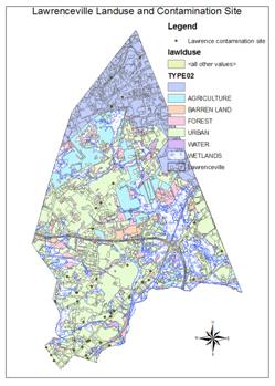
wall paper is the GIS plot of Council Rock School, PA tax for each parcel
ENV-205: Introduction to Geographic
Information Systems, Fall 2020
My office is located in
Science Building, room 323C. However, office visit this semester is expected to
be all virtual. You can email me and I can schedule a zoom virtual meeting with
you. The times I am definitely AVAILABLE (office hrs)
are: Tuesday, Thursday morning 10-11:00 AM, Wed 10-11 AM. Other times, I might
be available and you need to schedule.
Synchronized Zoom Class
Period: Monday 1:10-4:10 PM. You might be able to use computers in classroom
S334 after the 1st three weeks(Not sure).
E-mail: hsun@rider.edu
Objectives
The course will provide students the experience in creating, manipulation, managing, analyzing, and presenting spatial information using Geographic Information Systems (GIS). Additionally, students will gain experience in applying GIS capabilities to investigate environmental and social issues.
Course Description
This course introduces the computer-based concepts and skills of Geographic Information Systems (GIS). It covers the GIS concepts such as map characteristics and projections, spatial data models, relational databases, and spatial analysis. It explores sources of data, data quality and metadata, implementation and management of GIS projects. Hands-on experience with ArcGIS is provided through a series of exercises completed by students in the course. Students will be taught how to process both vector and raster data using ArcGIS 9 software. The course will support disciplines of natural science, business, and social studies that require spatial information.
Class Format
The class will meet once a week for three hours. Zomm lecture will focus on the conceptual basis of GIS analysis, introducing concepts and principles needed for effective GIS use. The in-class exercises will provide students practice in using ArcGIS 9 software in a problem-solving environment.
Prerequisites
There are no prerequisites for the course.
Tentative Class Schedule
Week
1 (Aug 31) Introduction to ArcCatalog and ArcMap.
Browsing
GIS files, metadata in ArcCatalog folder. ArcMap environment
Week
2 (Sept 7) Map projections, coordinate systems.
Maps
and their characteristics, coordinate systems. Map in ArcMap. Adding and
removing layers, dock and undock toolbars and buttons.
Week
3 (Sept 14) Working with tables.
Types
of data, relational database. Database and attribute tables for features and
Images. Data fields
Week
4 (Sept 21) Attribute and spatial queries, and query language.
Query
from attribute table, definition, wildcard, and overlay queries. Advanced
calculations.
Week
5 (Sept 28) Spatial Joins
Feature
joins and table join, types of data conversion and adding thematic layers, map
overlay, graduated colors, and symbols.
Week
6 (Oct 5) Basic Editing in ArcMap
Vector,
Raster and TIN data models. Dot, line, polygon, cell and grid.
Week
7 (Oct 12) Continuing editing features in ArcMap and ArcToolbox
Map
scale, layout. ArcTool, conversion and accuracy
change.
Week
8 (Oct 19) Creating map in ArcMap
Create dot, line, polygons, and labels. Switching layers, and multiple data frame, save layers and project. Polygon-on-polygon overlays and geoprocessing.
Week
10 (Oct 26) Geoprocessing
Separate
and integrated data. Intersect,
Week
11 (Nov 2) Geocoding and address matching
Managing
geocoding services, and process. Geocoding table of addresses, finding,
matching and rematching addresses.
Week
12 (Nov 9) Raster Analysis.
Raster
display, pyramid and georeferencing. Grid files and reclassing a grid. Digitial elevation grid (NEM files) using Spatial Analyst.
Week
12 (Nov 16)
Raster
Analysis.Creating customized maps
Students
design and create a database and thematic maps
Operations
on the customized map. Query, filter and buffer.
Spatial
filters & buffers
Using
theme as a spatial filter, hammer tool. Create buffers from attribute tables.
Buffer tables, and queries.
Week 13 (Nov 23) ArcGIS pro
Week 14 (Nov. 20) Final exam and Starting final project
Final Project Due Day: Dec
7, Monday 5:00 PM
Grading Policy
The final
course grade is based on a set of applied course projects, in-class exercises,
homework assignments, and a final exam. The weight percentages are:
In-Class
Exercise and Projects: 65% (each class project + exercise counts ~ 6 (70/30)
points). Unless instructed otherwise, all late assignments
will be penalized 10% per day. Attendance 5%. Final exam 15%/. Final
project: 20%.
My grading policy is as follows: A range >90, B
range 80-89, C range 70-79, D range 60-69, F range <60. "Borderline" cases will be judged
individually, based on grade improvement, demonstrated effort and class
participation, etc.
Price,
M., 2019, Mastering ArcGIS, (8th ed.), McGraw-Hill.
Optional
Reference Book
Bolstad, P., 2005, GIS Fundamentals: A First Text on
Geographic Information Systems (2nd ed.), Eider Press.
Zoom Attendance Is
Required. Regular
attendance makes a big difference in the final grade received. The material in
this class is cumulative. If you miss a day, you may find that you are lost during
the next lecture. Three unexcused absences will result in a drop of your final
score by 5 points. Excessive unexcused absences will likely result in a grade of F (due to
unfinished projects). Excuses for absence will be granted for approved athletic
participation, approved field trips, a certified serious illness, death in the
immediate family and military examinations. Absence from class, no matter what
the reason, does not grant the student a chance to make up the in-class
exercises. Instructor′s permission for withdrawal will be given only for
exceptional circumstances. Make-up projects are generally NOT ALLOWED for
unexcused absence.
Note: In order to be excused for
an absence, you must have documentation to validate your excuses. For example,
if you are sick, you need a doctor′s note to show me. If your car broke down, you need a slip
from the towing company or your mechanics.
Cheating: Academic
integrity is highly valued at Rider. Students caught cheating for a project
will be given a "zero" for that project. Repeated offender will be
given an F for the course.
To Geology Department Homepage
To Dr. Sun's Homepage|
E-mail Dr. Sun: hsun@rider.edu
Last updated 8/26/2020